Beverly Gardens Park is 22 block long and stretches along Santa Monica Boulevard in Beverly Hills, California for 1.9 miles (3.1 km). It was designed by landscape architect Ralph D. Cornell
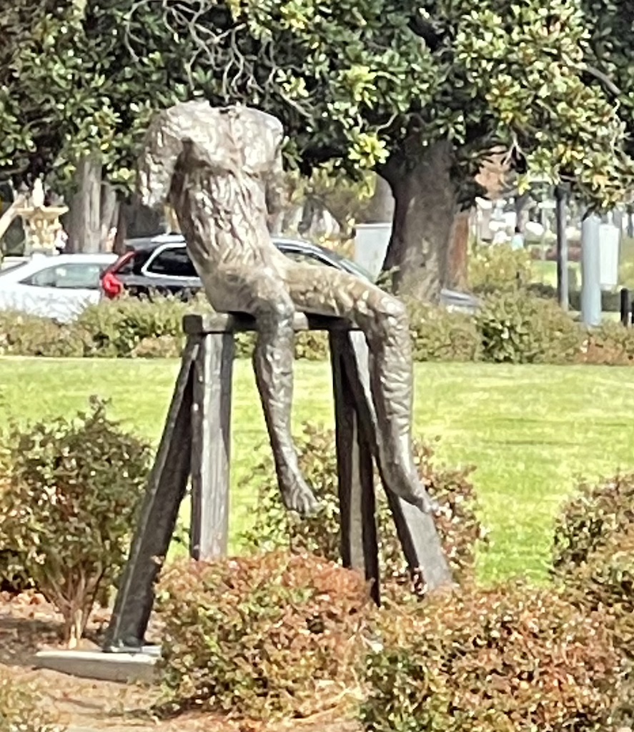


Beverly Gardens Park is 22 block long and stretches along Santa Monica Boulevard in Beverly Hills, California for 1.9 miles (3.1 km). It was designed by landscape architect Ralph D. Cornell
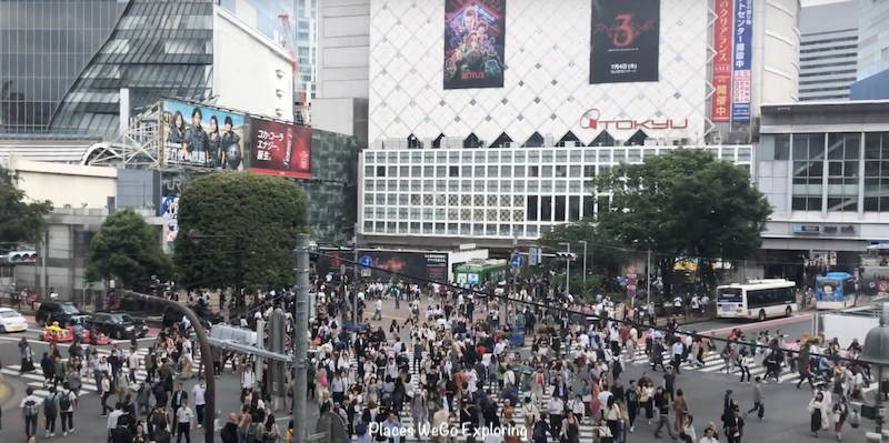
Tokyo’s iconic intersection! Shibuya’s scramble crossing is where people pour in from all directions and where we witness less vehicles and more pedestrians crossing the intersection.
We witnessed the iconic crossing from the vantage point Starbucks and did the crossing too. It was an unique experience.
It is like Times Square of NYC. The Billboards, the pedestrian crowd and the towering buildings around you – all transport you to a different world altogether. Shibuya Crossing, or Shibuya Scramble Crossing, is a popular scramble crossing in Shibuya, Tokyo, Japan. It is located in front of the Shibuya Station Hachikō exit and stops vehicles in all directions to allow pedestrians to inundate the entire intersection. The statue of Hachikō, between the station and the intersection, is a common meeting place and almost always crowded. The 2012 SOTO Outdoor Media Survey estimated 1.5 million pedestrians per week.
Do you want to be the one in the 1.5 million pedestrians? Don’t forget to visit Shibuya Crossing on your visit to Tokyo and you would be amazed at witnessing the crowd thronging the intersection.
Watch our experience in walking the iconic intersection:
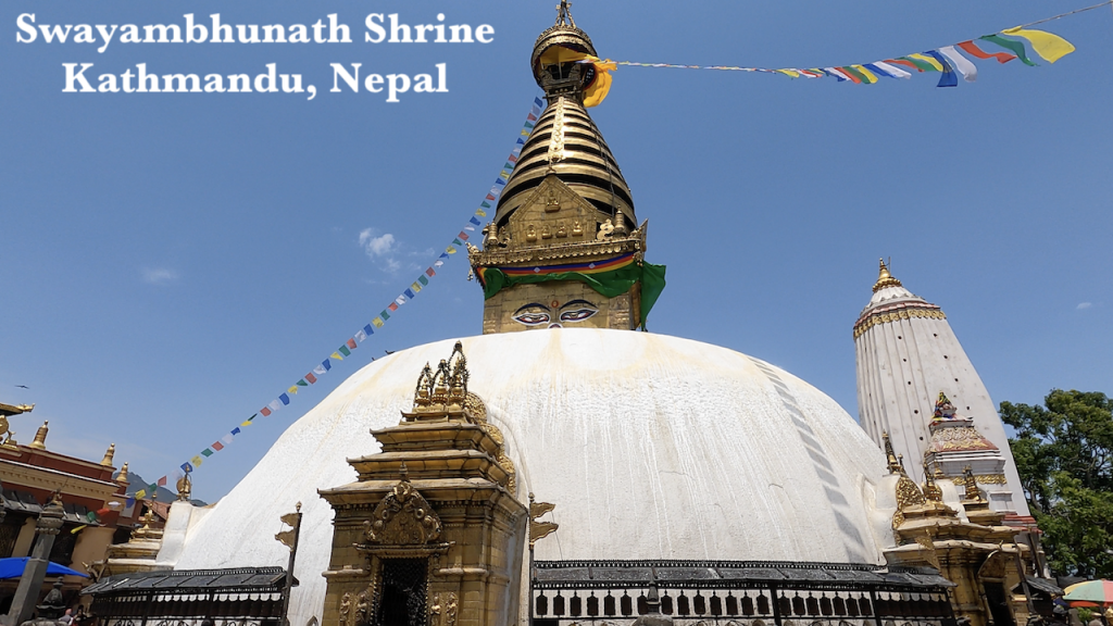
Swayambhu, means ‘self-sprung’. The buddhist shrine in Kathmandu, Nepal is the oldest religious site and was founded by King Vṛsadeva about the beginning of the 5th century CE. (Common Era)
Also known as Monkey temple, this shrine is among the oldest religious sites in Nepal and is visited every day by numerous tourists and locals. Swayambhunath Stupa is a 2000 years old Buddhist monument & UNESCO cultural world heritage site.
There is small fee to enter the site. For people from SAARC countries, it is 50 Nepali rupees and for other countries, the fee is 200 Nepali rupee (about US $1.50)
What is SAARC?
SAARC stands for South Asian Association for Regional Cooperation and its member states are Afghanistan, Bangladesh, Bhutan, India, the Maldives, Nepal, Pakistan and Sri Lanka. The purpose of SAARC promotes the welfare of the peoples of South Asia, strengthen collective self-reliance, promote active collaboration and mutual assistance in various fields, and cooperate with international and regional organizations.
The temple is in the uphill overlooking Kathmandu Valley. We walked up through the side walk shops and came down through the eastern 365 stairways where you get to enjoy viewing a lot of monkeys. Monkeys are considered sacred and holy here.
The main stupa:
Single plinth base stupa contains womb, dome, Harmika, wisdom with compassion eyes to four directions, third eyes, 13 spares, and pinnacle. Buddha’s third eye
Buddha’s (Two for external journey and one for internal journey)
Although the site is considered Buddhist, the place is revered by both Buddhists and Hindus. Numerous Hindu monarch followers are known to have paid their homage to the temple, including Pratap Malla, the powerful king of Kathmandu, who is responsible for the construction of the eastern stairway in the 17th century.
The stupa was completely renovated in May 2010, its first major renovation since 1921[5][6] and its 15th in the nearly 1,500 years since it was built. The Swayambhu Shrine was re-gilded using 20 kg of gold. The renovation was funded by the Tibetan Nyingma Meditation Center of California, and began in June 2008.
At around 5 a.m. on 14 February 2011, Pratapur Temple in the Swayambhu Monument Zone suffered damage from a lightning strike during a sudden thunderstorm.
Watch our trip to this beautiful temple:
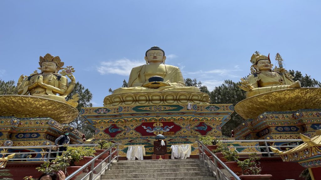
Buddha Park featuring the biggest Buddha Statue in Nepal near Kathmandu is a sight to look at feeling mesmerized and enthralled. The golden statue of Buddha sitting tall in the middle measuring 67 feet from the ground with a bowl of nectar is a great work of art. The meditative pose of Buddha along with Shakyamuni Buddha on the left and Guru Rinpoche (aka Guru Padmasambhava) make a perfect trimurthis to look at feeling peaceful at hear and mind.
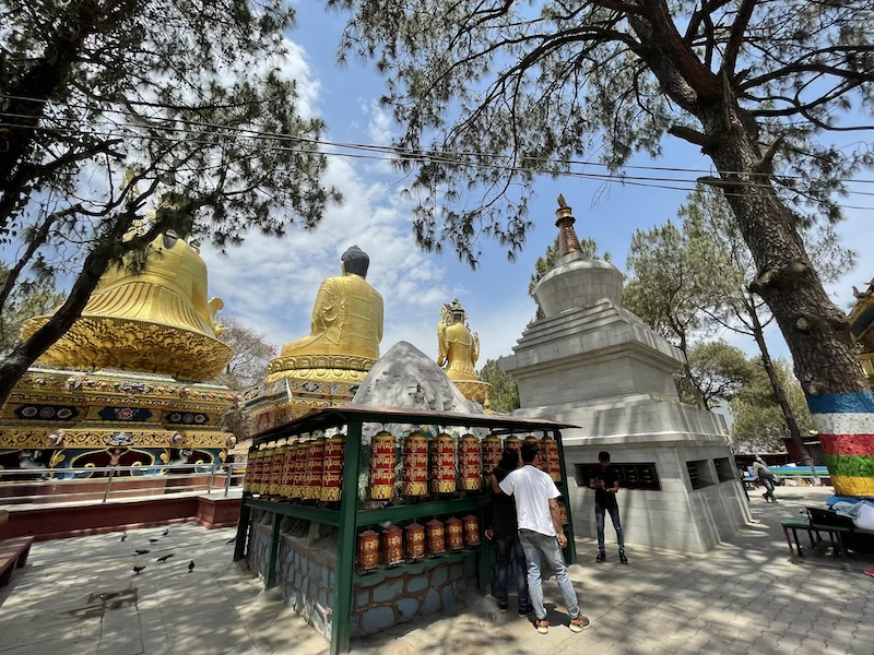
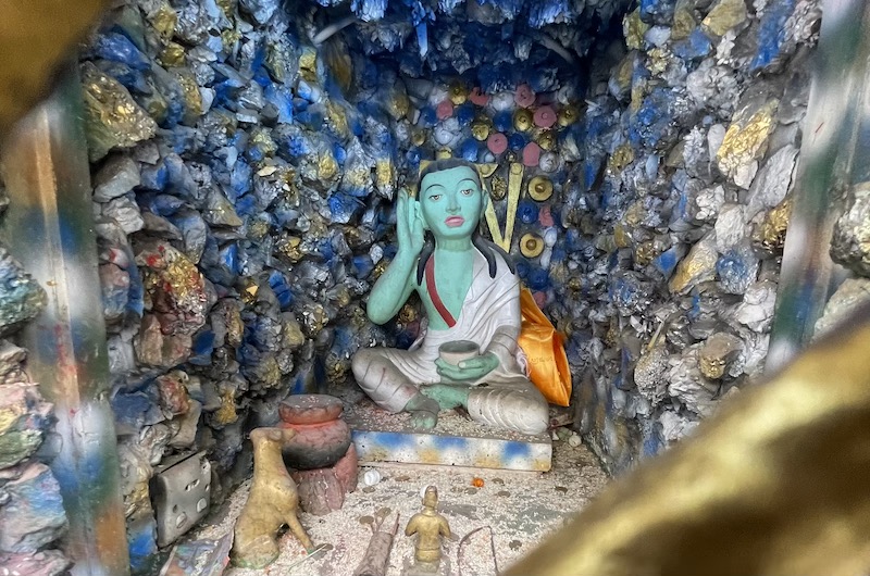
The artist who carved the statues is Kunsang from Bhutan. A short distance from the most famous Swayambunath Temple, Amideva Buddha Park was built in 2003. Please take time to explore around the park and you will get to spin the prayer wheels all around the park chanting “Om Mani Padme Hum” and see Mount Kailash and Lord Shiva with Nandi and the statue of Milarepa, (1052 AD – 1135 AD) one of the most famous Tibetan Masters, a great saint and a spiritual poet in a meditative pose inside a shrine.
Watch our visit to this Trimurthis Temple:
Homage to La Ballona Creek is a large sundial positioned at 32 degrees, the latitude at which Culver City is located. Set at the top of the hill, the views of the city are brilliant from here and you will be a little away from the buzz of the city below. There is a friendly trail accessible to the people with strollers & wheelchairs.
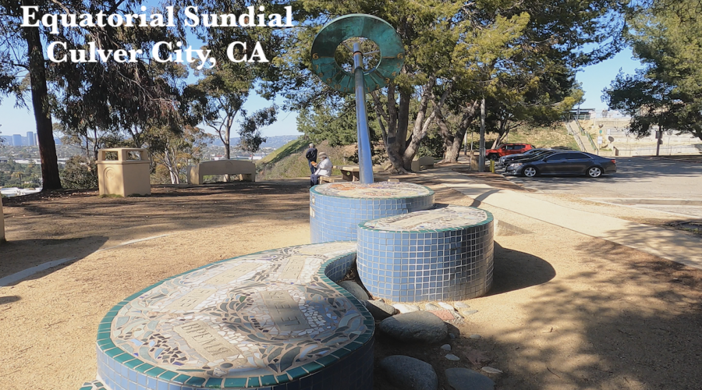
Equatorial Sundial is a dial in which the dial plate is parallel to the equatorial plane and the polar-pointing gnomon is perpendicular to it. The equatorial sundial is the simplest of all the sundials. It can be made without mathematical calculations and can be used at any latitude.
Artist Lucy Blake-Elahi, (assisted by 6th grade students from Echo Horizon School), created colorful tiles that include references to animals and vegetation that once inhabited the area. These tiles are incorporated in the artwork around the base of the sundial. Quotations representing the diverse languages spoken in Culver City also surround the base of the sculpture. The sundial can be read from the south side in the winter and the north side in the summer.
Lucy Blake-Elahi is an arts educator and Culver City resident. She was a collaborator on two mural projects along Ballona Creek, Postcards from Ballona (1997) and Rivers of the World (1996).
The text on the plaque reads:
“THE EQUATORIAL SUNDIAL
The slant of the dial is the same angle as the equator. The long tube, the GNOMON (no-mon), casts a shadow on the dial as the sun moves. It is set at an ANGLE of 34 DEGREES – the latitude of Culver City. It is facing true north (Polaris, not magnetic north).
“HOW TO READ THIS DIAL
The top side (north face) is set for daylight savings time (D.S.T) and is read from March 21 to September 23. The under side (south face) is set for Pacific Standard Time (P. S. T.), and is read from September 24 to March 20.
“READ FROM THE CENTER OF THE SHADOW
This dial shows LOCAL APPARENT TIME, therefore it will appear slow or fast at different seasons. Variation will arise from the fact that the Earth moves more swiftly in orbit closer to the sun than when farther away and, because the sun’s apparent path is elliptical. The difference between your watch and this dial is called THE EQUATION OF TIME.”
Watch our trip to this great location:
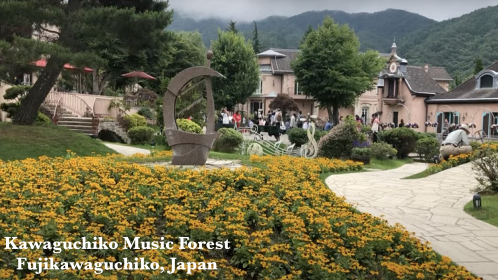
The Kawaguchiko Music Forest is located at the foot of Mt. Fuji with beautiful Lake Kawaguchiko and Mt. Fuji in the forefront. European-inspired garden with an antique music-box museum, vintage organs & live performances, this place is a good choice for visitors who want to spend their quiet afternoon.
Kawaguchiko Music Forest is a one of a kind musical theme park, designed with a “European Alps” atmosphere standing beneath a superb view of Mt. Fuji. It holds a world-class collection of automatic musical instruments, including the world’s largest “dance organ and doll orchestra” and the Philharmonic Performance Orchestrion designed for the Titanic.
Stroll through the seasonally themed, art, and rose gardens, or take in the scenery from the comfort of the restaurant-cafe and shops. With the price of admission, you can also enjoy various musical experiences throughout the day. Particularly interesting are the automatic instrument demonstrations, and one of a kind live performance of musicians and opera singers. Also, experience the sand art storytelling artists backed by live musicians. This park is for all ages, enjoyable in all seasons, rain or shine.
Please watch our trip to this wonderful music museum:
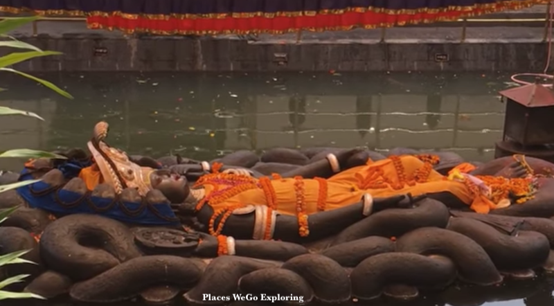
Budhanilkantha Temple is situated below the Shivapuri Hill at the northern end of the kathmandu valley. Sleeping Vishnu is carved on a huge black stone. An interesting feature of this shrine is that when Nepal was a Kingdom, the reigning King of Nepal was not to visit the spot according to an old tradition. The statue of Budha Nilkantha is considered the largest stone carving in Nepal. The temple is also known by Sleeping Vishnu Temple & Jal Narayan Temple.
Interesting Facts:
(source: https://www.nepalisansar.com/culture/10-important-facts-about-nepals-budhanilkantha-temple)
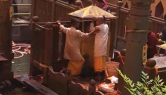
The Budhanilkantha Temple has become the site where Haribondhini Ekadashi Mela takes place on the 11th day of the Hindu month of Kartika (October–November). Attended by thousands of pilgrims, it is the temple’s principal festival in celebration of the awakening of Lord Vishnu from his long sleep.
1) Budhanilakantha is a Sanskrit word that means ‘Old Blue Throat’, a title of Lord Shiva that was given by gods after the Lord drank poison to save the world.
2) The temple houses the country’s largest and most beautiful stone-carved idol of Lord Vishnu believed to have been made with a single block of black basalt stone of unknown origin.
3) The sculpture is 5 meters long and lies in a resting position in a 13-meter long pond also called as a ‘cosmic sea’.
4) Vishnu idol in the lake was believed to have been built during the reign of the 7th century monarch Vishnugupta, who controlled the Kathmandu valley, 1400 years ago.
5) Records also show that the temple has been rediscovered later during the early Malla Dynasty period by a farmer and his wife.
6) The water in Budhanilakantha is believed to have originated from Gosainkund, a lake formed as a result of Lord Shiva’s trident striking with the mountainside.
7) Local legend describes the existence of mirror-like image of Lord Shiva on the statue’s underside.
8) The Lord Vishnu statue shares feature similar to that of Lord Buddha.
9) Thousands of pilgrims visit the temple during Haribondhini Ekadashi that is held during the 11th day of the Hindu month of Kartik (October – November), every year.
10) A big fair is also held at Budhanilkantha every year on the auspicious days of Ekadashis, Harishayani and Haribodhini, marking the 4-month sleeping period of Lord Vishnu as believed by Hindus.
Happy Traveling & Exploring!
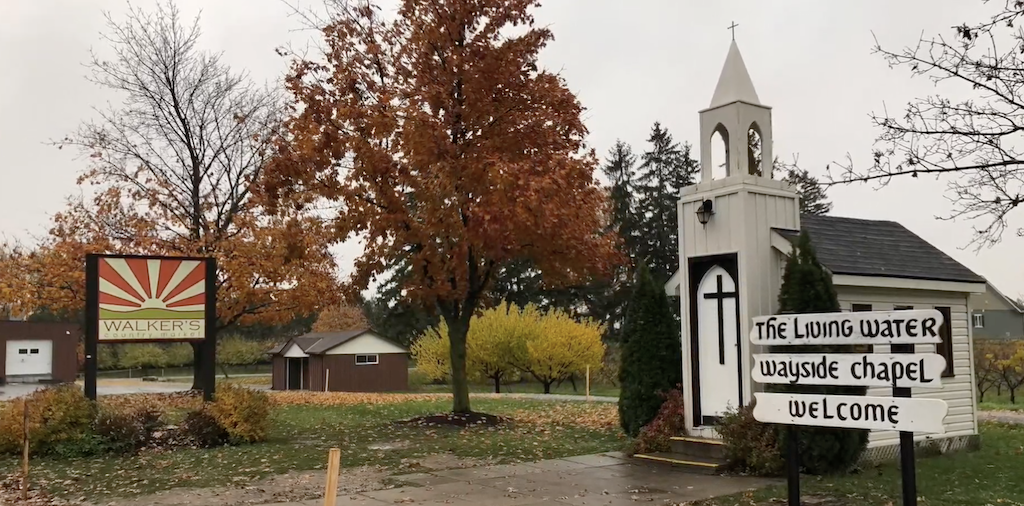
Name: Living Water Wayside Chapel
Hours: Open to visitors 24/7
Location: Niagara-on-the-Lake, Ontario
Country: Canada
What a great place to get hitched……😁😍
If you are looking for a cute and quiet place to get hitched, head over to Ontario and visit this chapel. The chapel and the surroundings won’t disappoint you and your fiancé.
This lovely cute chapel holds only 6 people inside and outside the great lawn and the trees will make a perfect set up for the guests. Our guide confirmed to us that such weddings do occur there.
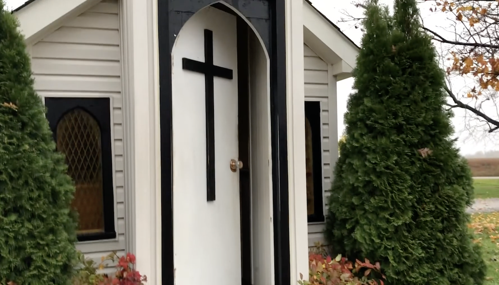
This charming chapel is a tiny sanctuary for tourists seeking a moment of peace and respite from the road. From the outside, it looks more like a child’s playhouse than an active church.
We can’t really confirm about this chapel being the world’s smallest chapel but this 72 square feet chapel is a absolute delight to visit.
The chapel was originally built in 1964 by the Niagara Falls Christian Reformed Church. It was meant to serve as a worship space for tourists in the region. The structure was moved in 2012 to its current location for renovation, but it is unclear who currently manages the chapel. No website exists for the church or the congregation.
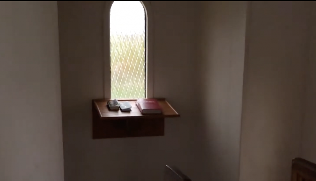
After ducking your head down while entering the archway, you’ll see that the inside of this miniature worship space holds four short pews as well as two Bibles and a guest book. Visitors can say a quick prayer in the chapel and walk next-door to Walker’s Country Market for fresh produce. Weather-permitting, every Easter guests can join a sunrise worship at the chapel. The space is also available for intimate wedding parties of about six people.
Watch our visit to this cute chapel:
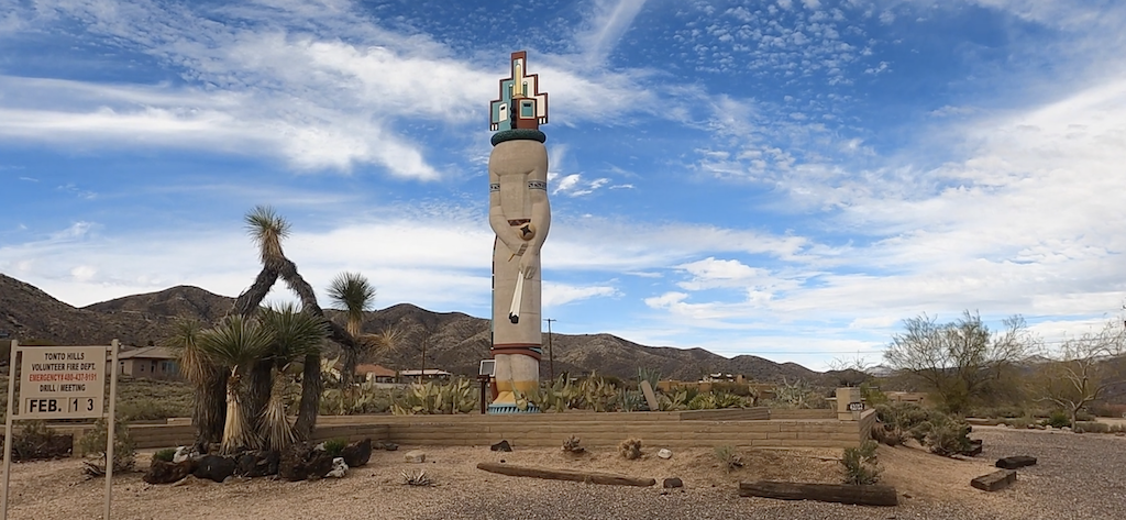
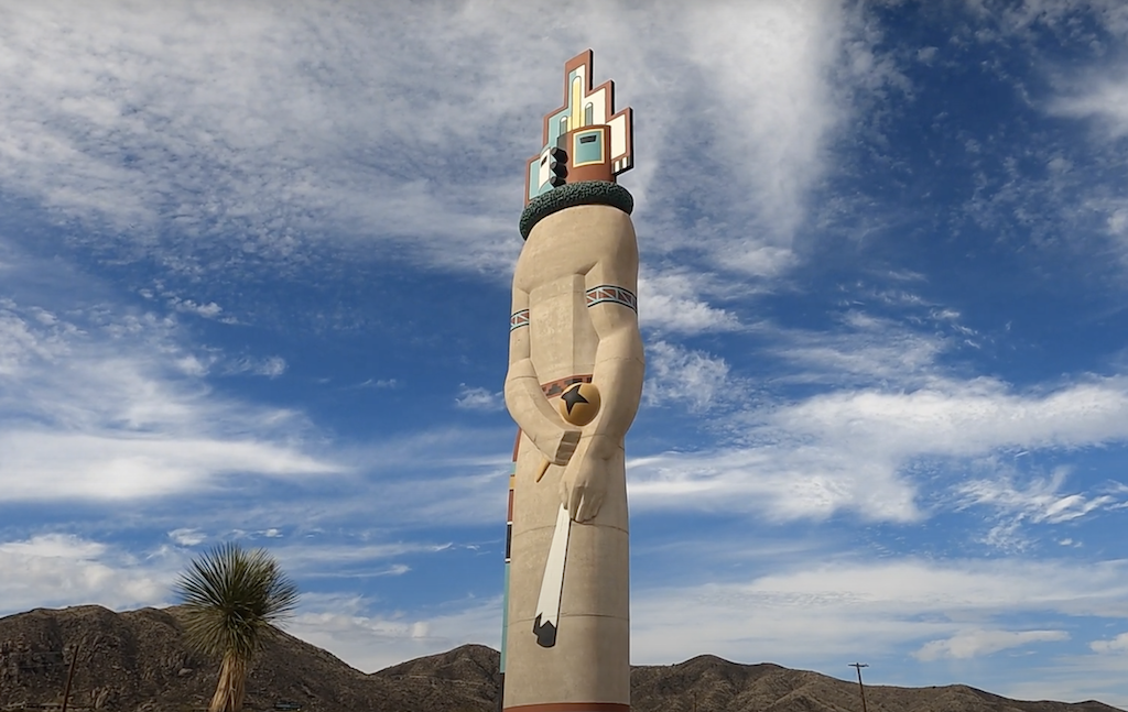
An impressive World’s Tallest 39′ Kachina Doll stands tall in the neighborhood of Tonto Hills, near Cave Creek, Arizona. It is definitely an interesting roadside stop near Cave Creek, Arizona to pause & appreciate Southwestern culture & history.
They were originally designed to teach young members of the Hopi tribe about spirit beings known as Kachinas, which control the rain, the crops, and countless other things. Hopi katsina figures also known as kachina dolls, are figures carved, typically from cottonwood root, by Native American Hopi people to instruct young girls and new brides about katsinas or katsinam, the immortal beings that bring rain, control other aspects of the natural world and society, and act as messengers between humans and the spirit world. It’s important to note that Kachinas, and the dolls which were made to symbolize them, were not intended to be worshipped- only respected.
The katsinas are known to be the spirits of deities, natural elements or animals, or the deceased ancestors of the Hopi. Prior to each katsina ceremony, the men of the village will spend days studiously making figures in the likeness of the katsinam represented in that particular ceremony. The figures are then passed on to the daughters of the village by the Giver Kachina during the ceremony. Following the ceremony, the figures are hung on the walls of the pueblo and are meant to be studied in order to learn the characteristics of that certain Kachina.
Edward Kennard, co-author of Hopi Kachinas, says concerning the purpose of the kachina figure, “Essentially it is a means of education; it is a gift at dance-time; it is a decorative article for the home, but above all it is a constant reminder of the Kachinas Now, it has lost most of the symbolic power the Hopis originally intended for it and is a common site at trading posts, gift shops, and other Southwestern-themed commercial enterprises.
Donations are accepted to maintain the kachina doll and help fund the advance training for fire fighters.
Watch our visit to this impressive location: